Reprinted
from Sierra Leone Studies, NS No. 16, June 1962
An
Account of the Liberian Hinterland c. 1780
By P. E. H. Hair
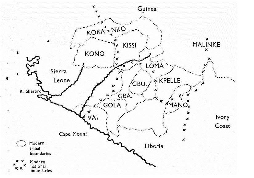
The details of the route are slight. " He travelled first into Mannah country and then into Gurah, but in the course of his travels, which were in a N.E. or E.N.E. direction, he passed through several countries the names of which he did not recollect. Those he was best acquainted with, and which he named in the order of his route were Gurah, Candoh, Beysee, Plai, Boosee, Gissee, Jolissee and Mangro. Gissee (or as it is most commonly pronounced Kissee) was that in which he resided longest." This list of " countries " is the most certain part of Harrison's account, for we can identify from it, with fair ease, most of the tribes of the hinterland of Western Liberia, that is, the region N.E. and E.N.E. from Cape Mount inland for about 300 miles.
The " Mannah " is the river slightly to the west of Cape Mount: there is no Mannah tribe, but Mannah country was no doubt the lower course of that river inhabited by part of the Vai tribe. "Gurah " is certainly Gula or GOLA 1 the tribe which today occupies a position N.E. of Cape Mount, immediately behind the coastal Vai. " Candoh " may be a variant of Kondo or KONO, but today this tribe begins a hundred miles further north, and therefore to the west of the N.E. route indicated. However in the nineteenth century, a district much nearer to Cape Mount was known as Condoh Country, and this is likely to be the district Harrison passed through.2 According to Büttikofer, in the 1880s Condoh Country
 was around Boparu, about one
hundred miles N.E. of Cape Mount. (Today this is part of Gola country
and I have not come on an explanation of the earlier name.)
was around Boparu, about one
hundred miles N.E. of Cape Mount. (Today this is part of Gola country
and I have not come on an explanation of the earlier name.)The next tribes mentioned are the " Beysee, Plai, Boosee " and " Gissi ". Today the KISSI are encountered roughly 150 miles N.N.E. from Cape Mount. Between the Gola and the Kissi are three small tribes, somewhat intertangled, named from west to east, the Gbande, the Gbunde and the Loma: and immediately further east,
1 All tribal names are taken unless otherwise stated from D. Westermann and M. A. Bryan, Languages of West Africa, 1952.
2 J. Holman, Travels, 2nd edition 1840 [in Liberia 1827], p. 140, J. Büttikofer, Reisebilder aus Liberia, 2 vols., Leyden, 1890, I map, II pp. 186, 237.
The last two tribes listed are more difficult to identify. The " Mangro " might conceivably be the tribe immediately to the east of the Kpelle, the Maa or MANO, but the form Mangro is not indicated in any of the sources. Driven to search further, we note that the syllable " man " might indicate a link with the people known variously as Mani, Mane-nka, Mali-nke, or Mandingo. To the north and east of the Kpelle are sections of this people, but none today appears to bear the name "Mangro ". However, there is a section which is called Jula or DYULA, a section which trades among and has to some extent settled among the tribes of upper Ivory Coast, east of the Mano and Kpelle. We suggest that the Jolissee are the Dyula. We have not found a form Dyula-si, but a possible form Dyula-fi might indicate that Jolissee was a misprint for Joliffee ( the printer may have gone wrong after Gissee...Jolissee).3 If it be accepted that Harrison moved east of the Kpelle, among these Malinke-speaking groups of Ivory Coast, then another explanation of the Mangro is available. De Tressan reports that in central Ivory
1 Büttikofer, op. cit., I p. 168 and map, II p. 187.
2 And why " bey " instead of " bay "? Or if it was intended to rhyme with " key ", why not " bee "?
3 " Fĩ " is attached to the names of several tribes in this region (e.g. Bobo-Fĩ = black Bobo) and Westermann reports that a section of the Dyula are called Da-fĩ. Dyula-fi does not appear in any account but is not implausible.
Coast, near Katiola, a very small non-Malinke group calls itself " Mangoro ".1 Today there are only
The tribes which Harrison claimed to visit are therefore those now officially known as Gola, Loma, Kissi, Kpelle and possibly Mano, Dyula and " Mangoro ". A journey from tribe to tribe in the order listed by Harrison would be perfectly possible today: the journey would be reasonably direct and generally E.N.E. from Cape Mount. It would be rash to assume that in 1780 the tribes were the same, had the same names and were located in the same positions as is the case today; and it must be recollected that there is no direct or independent confirmation of Harrison's journey. But his list fits in so well with the modern disposition that it is impossible to resist the conclusion that his information was reasonably accurate and that in the main the tribes at that date were the same, with the same names, in the same places. Belief in the veracity of Harrison's account is considerably strengthened by the fact that the Liberian hinterland was in 1780 unknown country. As far as is known, the names Kpelle, Buzi and Kissi had not appeared in print before. If his story be accepted, Harrison was probably the first white traveller in this part of the Guinea hinterland and certainly the first person to have his travel recorded. The next white travellers in the vicinity were Major Laing who in 1822 reached Koranko country immediately west of Kissi, and Rene Caillié who in 1827 passed to the north
1 de Lavergne de Tressan, Inventaire Linguistique, de l'AOF, Mémoires de l'IFAN No. 30, 1953. In 1766, a missionary in the West Indies collected a vocabulary of " Mangree ". Unfortunately he only stated that " Mangree " was spoken " deep inland " apparently somewhere behind the Kru and the Akan. The words in the vocabulary appear to be of mixed origin: two are Akan, one is possibly Kru, and the rest though unidentified appear to be non-Mande. " Mangree " therefore throws little light on " Mangro ". G. C. Oldendorp, Geschichte der Mission...auf den caraibischen Inseln..., Barby, 1777, Table and p. 277, J. G. Christaller, " Die Sprachen in dem Negerfreistaat Liberia, " Zeitschrift für afrikanische Sprachen, II, 1888-9, pp. 315-20.
Harrison's account of the region he claimed to have had travelled through was a very brief one, being less than 1,000 words. As he admitted, he had confused the particulars of the different tribes, and he spoke therefore as if the region were alike in all parts in all respects. Many of his general remarks are not very revealing, but it is noteworthy that almost all of them apply at least to Kissi country, the district in which he claimed to have lived longest.
His geographical references were few. In Kissi country, he was told that he was not far from a source of the Gambia river. Kissi country occupies part of a watershed from which descend many lengthy rivers, but the Gambia rises on the western edge, several hundred miles away. The rivers which rise in and around Kissi country are more important than Harrison realized in 1780: even in 1808, when his account appeared, it was not appreciated that these are the sources of the Niger. They were not explored till the 1820s. At another point in his narrative, Harrison remarked that the rivers in the interior were wide, particularly the tributaries of the Sherbro River. The three large rivers of the coast between Sherbro Island and Cape Mount were known only in their lower courses in this period. The Sherbro or Deong River is the one with the most western course and does not touch Kissi country: the river which penetrates further inland and further to the east and therefore into Kissi, is the Moa. It is possible that the identification of the inland river as the Sherbro was not Harrison's but Ludlam's.
"These countries were in general flat and the soil sandy and covered with grass. Where rising grounds and wood-lands occasionally intervened, the soil was better. In such places, especially on the summits of hills, the people built their towns. " This description could apply to Northern Kissi-land which consists of bare plateaus, broken up by steep hills and wooded valleys. Villages are still built on the side of hills.2 Further south, where the land becomes more forested, the description would not apply. " Timber is everywhere extremely scarce: in some places nothing deserving the name of a tree can be found." Again, this could only apply to a district north
1 A. G. Laing, Travels in Timannee, Kooranko and Soolima countries, 1825, R. Caillié, Travels through Central Africa to Timbuctoo, (English translation) 1830, vol. I, pp. 282-3, J. K. Trotter, The Niger Sources, 1898, p. 35.
2 D. Paulme, Les gens du riz: Kissi de Haute-Guinée, Paris 1954, p. 15.
of the forest. These two references would suggest that Harrison was generalizing mainly from his
"They have no gold-mines nor did that metal appear common: though he had sometimes seen very large Manillas and other ornaments made of it." The main gold-mining area of this part of West Africa is north of Kissi country, in the Buré district of the Niger. But gold has also been mined for centuries in Kpelle country, and export of gold through Cape Mount was noted around 1500.1 The remark could therefore only apply to the north-west portion of the Liberian hinterland, that is, in Kissi again. "They smelt their own iron and make steel [sic] of an extraordinary hardness. " Iron-smelting was formerly wide-spread in West Africa, but has disappeared in many districts in recent centuries. Portuguese writers around 1500 spoke of iron reaching the Sierra Leone coast from the interior.2 Today there is said to be no iron-smelting in Kissi country,3 whereas Kpelle country is renowned for this art: however it is not at all unlikely that it has died out in Kissi since European commerce reached there.
So far Harrison's remarks may be taken to refer accurately at least to Kissi country, if not to the whole of the Liberian hinterland. But the next reference is more difficult to accommodate. " A species of cassava, differing in some degree from what is common here [on the coast], together with the flesh of wild animals, formed the chief food of the countries inland. " The most recent work on the Kissi is entitled " Les gens du riz ", and rice which Harrison ignores, is today either the main crop or at least is cultivated as extensively as cassava, throughout the whole region. Since rice was cultivated on the coast and in the Niger valley many centuries earlier, whereas cassada was only introduced into West Africa in the fifteenth century, it is very unlikely that an interior district, capable of growing both, in 1780 had cassava but no rice. That cassava was cultivated in the hinterland, as Harrison says, seems reasonable: but a quirk of memory or an error in communication must have been responsible for the failure to mention rice.4
"Their towns are often large and strong: being guarded by a
1 R. Mauny, Tableau géographique de l'Ouest Africain au Moyen Age, Mémoires de l'IFAN No. 61, 1961, pp. 293-306.
2 Ibid.; pp. 313-7.
3 Paulme, op. cit., p. 62.
4 In the 1820s, Kissi-land cultivated " a great quantity of rice". R. Caillié, op cit., p. 283.
"Canoes are little known, but the rivers are crossed on rafts...which are towed across by means of a species of vine or creeping plant, 9 or 10 inches in circumference, which is stretched from bank to bank...The great difficulty is to extend it across the river. None but headmen can undertake such work..." Bridges built wholly or partly of vines were noted by nineteenth century travellers in the hinterland, and have been described recently as found in Kissi land. 4 Many vines are twined together (not a single stem as Harrison implied) and the result is normally a bridge over which foot-passengers hazardously pass rather than a towing-guide for rafts. However heavy loads would have to cross the river on rafts, and the " vine " might well be used to assist their passage. That Harrison does not refer to the " vine " as a bridge is curious. The authority on the
1 e.g. Büttikofer, op. cit., II, p. 197, illustration of a quadruple palisade at Cobolia in Vai country.
2 Paulme, op. cit., p. 55.
3 V. Fernandes, Description, edited at Bissau 1951, pp. 49, 91.
4 e.g. A. G. Laing, Travels in Timannee, Kooranko and Soolima countries, 1825, p. 213, T. J. Alldridge, The Sherbro and its hinterland, 1901, p. 286. cf. "They have here and there a sort of bridges, made with staffs of tomboe [vine], tied close together, and over them, on each side, about three foot high, a long rope made of certain roots twisted, to preserve the travellers from falling into the river. These bridges are fastened at each end, on the land, with the same sort of ropes, made very strong and fixed to trees." J. Barbot, Description of Guinea, 1746, p. 119.
Kissi writes--" These bridges are built at night in great secrecy, and very rapidly, by the initiated, that is the adult males..."1
"Their clothing is entirely of cotton, and in most countries, though not in all, they manufacture it
Two small points made by Harrison contribute to our history of the hinterland. " The manners of the inland countries differ little from those of our nearer neighbours: except that some tribes frequently change their habitations and wander about in bodies of 400 or 500 each. " We should like to know more about these wandering groups, since the history of the coastlands seems to indicate a steady infiltration of such up-country parties. In the hinterland in 1780, " the only exports are slaves and ivory: salt is the most valuable article which they receive in exchange: very little European merchandise, except guns and powder, having found its way so far inland. " Today, while European merchandise is imported into Kissi-land in increasing quantities, one of the most valuable trades remain in African hands, and this is the salt trade from the North.4
Harrison's account, most convincing in its list of names, vague but not notably incorrect in its general description except in the case of the absence of reference to rice, has a good claim to be accepted as the earliest account of the Liberian hinterland. That Harrison had lived on the coast there can be no reasonable doubt: but while
1 Paulme, op. cit., p. 16.
2 For detailed accounts of ordeals in the Mano tribe of N. Liberia, see G. W. Harley, Native African Medicine, 1941, pp. 153-168. According to Paulme, " red water " has only recently been borrowed by the Kissi from the neighbouring Koranko, Paulme, op. cit., pp. 163-4.
3 Paulme, op. cit., p. 44.
4 Ibid., p. 51.